 3rd Serbian Hot Air Balloon Open Championship & 9th Senta Cup will be on this weekend.
Competition map of Senta 2012 for OziExplorer is available from here.
The rules of the Event available from here.

The Competition map of Serbian Nationals is available from here:
Oziexplorer map image and calibration file.
Androzic map image and calibration file.
 I lost my Garmin GPS just before the Marijampole Cup. I had two possibility: buy a new one or find a suitable Android application. The second was the cheaper. I looked around the Android market because I knew no Oziexplorer application on Android. First I downloaded the TwoNav from the CompeGPS team but it’s free for two week only (after 42 EUR).
I wrote the Oziexplorer into the Android Market’s search box and the result was the Androzic app. The application promised what I need:
‘OziExplorer maps for Android. Tracking, waypoints, routes, navigation. Navigation client that uses OziExplorer maps (ozf2, ozfx3). Great for hiking, geocaching, off-roading, sailing, boating and other outdoor activities. You are expected to be aware of OziExplorer or at least of where to get its maps. Maps also can be created by yourself, but with some afford, see FAQ for details. Can work without maps as a simple navigator.’
Before using I had to convert the map file to Oziexplorer formats (ozf). The Androzic compatible with Img2ozf 3.03 or older version only. You may download the Img2ozf 3.03 from (or Img2ozf 2.08) here what I used and tested. If you are using ozf file already then in the Oziexplorer check your map’s projection: File / Check Calibration of Map. It works with Latitude/Longitude projection only (today version is 0.9.18b).
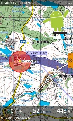
I had Androzic with calibrated Oziexplorer map already and it works well! 🙂 I used it for maping, waypoints for target places and navigation too. Everything was fine.
 Androzic application features:
• map index, switch between maps, zoom, drag
• works without maps as a simple navigator
• show current position, speed, course, elevation
• look ahead
• show current track, write track into file
• track recording in background (power-safe)
• edit track, view track details
• full track support
• full waypoint support
• full route support
• convert track to route
• project new waypoint
• create new or edit existing route
• load and save data files in in native ozi format
• load waypoints, tracks and routes in KML and GPX format
• navigation to waypoint and via route
• HSI and compass displays
• units configurable
• load best scale map automatically
• load arbitrary map
• show map and user grids
• search coordinates in various formats
• search waypoints, tracks, routes
• search locations via Google geocoder
• trackball and D-pad support
• portrait and landscape modes
• configurable paths
Two things is missing for me from the application:
I’m using it with a Samsung Galaxy S and I very like it. If you want to fly with Androzic you need an Android tab with a larger screen. The Androzic is free and an Android tablet much cheaper as an iPad. Have fun!
Dowload Androzic 2.3
Mapsforge maps download server